From our departure form the Bras d'Ore Lakes until we get to Halifax will require almost 200 nm of sailing with much of it along coastline that is rugged and has relatively few harbours for recreational boats. In fact, we planned to anchor our each night until we reached Halifax. Our final departure point from Nova Scotia will be Yarmouth or perhaps Clarks Harbour, and that will be almost 400 nm of sailing.
Large boulder inside Tor Bay
The conditions leaving St. Peter's were calm and favourable, but as we progressed through our 50 nm leg, the conditions became a little windier and the swells competed with the wind waves to create some very uncomfortable motion. Once and a while we were punching our bow through waves. Our first stop on this stretch would be Tor Bay. A large bay well protected from the prevailing SW winds.
Tor Bay
Berry Head light and breaking swells
As we approached Tor Bay we began to get a reprieve from the swells as we gained protection from Berry Head. We arrived a little while after Bob and he had already pulled right up to the south shore of the bay, just inside the point, and dropped anchor. We proceeded to pull up beside and raft.
Nasty shoal!
The anchorage was flat calm, but you could still hear the breaking swells from the point and the other side of the head. The ocean rarely sleeps even when the winds die.
Hartlings Island Our next stopover on the eastern shore was another 50 nm away. We have been scouring the charts and the ActiveCaptian resources along this shore to locate anchorages. While there may be 1000's of places to hide out and drop an anchor but seeing a location marked with an anchorage or having a review confirming good holding gives you peace of mind. The shores here are rocky, and unforgiving.
Hard to see but ...
Tuna fin in lower right of picture
We were able to knock two more types of sea-life from our list this day. At one point we passed a gently flopping dorsal fin at the surface very close to the boat. It had the distinct ridged pattern that looked more like a tuna fin than anything else we could determine. It remained at the surface and continued on behind us such that I gave Bob a call on the radio to give him a heads up. After talking to him later, he said he hadn't actually seen it, but did feel a lurch or something on the boat that made him feel as if he might have hit it.
Later in the afternoon at two different times we saw sea turtles go past the boat. They surface for just long enough for you to go and get your camera, but not long enough to get an actual picture of them.
Our destination was an anchorage tucked in behind Hartlings Island near Ecum Secum (competing for best place name we've found).
The anchorage was as described. We were well protected from any ocean swell, and had limited fetch on all sides. There was some tin boat traffic from local fishermen, and an abandoned cottage on the island, but otherwise it was just a seal or two to keep us company as well as a curious seagull that swam around just a few feet from the boats for quite a while perhaps hoping for a food scrap which we didn't provide.
In the morning, we awoke to varying thicknesses of fog, and as times we could barely see any of the land masses that surrounded us. The fog often comes and goes, thins and thickens, sometimes you can see blue sky if you look up. We decided to hold tight at this anchorage for another day to see if the fog would clear up for a morning departure the following day.
Morning fog behind Hartlings Island
By the time we awoke the next morning, we were still fog bound. We decided to delay our departure a little to see if it was going to clear up a little. Environment Canada does include references to fog on their marine forecasts but, as is their marine forecast in general, it's very terse and not always enlightening.
Eventually, while still hazy, we could see a comfortable mile or so in all directions, so we made the call to lift anchor and get ourselves underway.
Shelter Cover
Today provided a taste of what was to come along our journey along the south side of Nova Scotia. No sooner that had we gone a few miles, the fog filled back in and filled in thick. It varied little all day except when, at times, you could see 200' ahead, but most of the time barely more than 100'.
Our destination for the night was an appropriately named place called Shelter Cove. Our route would take us through a minefield of shoals, rocks and tiny islands.
Landforms only barely visible
The approach I use to navigate through this stuff is approximately as follows. The Navionics app (we all have this installed on our devices) provides an "auto-routing" feature that generally does a pretty good job at finding a reasonable path between two points. It has a preference to buoyed channels, but it is also happy to wind you though other more obsecure routes as long as there is deep enough water. After examination of the Navionics route, I manually enter my approximation of this into my Garmin chartplotter. I can then adjust waypoints for preference or for better clearance around obstructions.
Most of the time we couldn't
see Finnish Line at all
Actually following the route is a combination of letting the auto pilot follow the track, reverting to auto-pilot override, and occasionally manual steering. There is no question, letting the auto-pilot steer in this kind of fog does a way better job that a human. It usually keeps you withing 5' of the "pink line" and makes pretty snappy turns to each new waypoint. There are no reference points in this kind of fog. Steering by compass would result in small deviations in course as you wander and correct.
All of this requires double checking routes and waypoints, and cross referencing the chart plotter charts with the Navionics charts to be sure they are in reasonable agreement. You still need to do your homework and double check everything, at every zoom level!!! (remember Vestus)
Today there would be no sailing. There wasn't much wind, but
Typical navigation between
shoals and islands
our course meant that sails would have been a additional distraction and would further reduce the chance of seeing another vessel cross our path or a rock or island we hadn't anticipated. We had eyes peeled for boats (fishing boats typically don't have AIS) and ears listening for buoys, waves breaking on rock and other warning signs.
Finnish Line to windward
One thing we are very aware of is that marks are often not where they are charted. Not a big problem in good visibility, but now a bigger concern because these marks would appear out of the fog, sometimes right where you expected them, and other times not. Give the prevalence of fog along this shore, many of the outer mark have either bells or whistles. The bell buoys are straight forward enough. A large, 1' diameter bell with swinging gongs on the four sides. The whistle buoys sound more like bullfrogs. There is some sort of an air chamber and one way valves that trap air as the buoys sways and bobs in the swells. The air is then forced through an organ style pipe that has an oddly low frequency. Very effective as the sound travels long distances.
We crept our way into Shelter Cover. The entrance was only 300' feet wide, and the length of the cove was probably not more than 800' long. We had a few of these narrow channels to navigate today, so away from the wind and swell, this was no longer a navigational challenge. Now if we had relied on paper or electronic charts alone we probably would not have entered this cove. The charts all reported just a few feet of depth to get in. One of the very helpful additions to the electronic charting products you have now is crowd sourced reviews. We have relied on ActiveCapitan reviews for many of our anchorages and decision making on this trip. There was a recent posting that the depth into Shelter over was 20+ feet and that the charts were not accurate. We did proceed very slowly into the cove, but we didn't see less that about 22 feet.
Once our eyes had grown accustom to our surroundings, we could see we were not alone in the cove. There was another sailboat deeper in and a couple of hundred feet away, and we could only see it half of the time.
Always checking you out ...
but rarely caring
While we never did see much of the cove, we did have the company of a young seal that spent lots of time swimming and fishing near us. At one point I saw him playing with a fish he had caught by tossing it up in the air.
Jeddore Harbour (Myers Point)
Marks only become visible when
they're 100' away
Our last stop before getting to Halifax was Jeddore Harbour. Charts suggested some anchorages deep in that should have been very protected.
Fresh off a few days of fog navigation, we didn't hesitate in departing in the fog from Shelter Cove. We continued to exercise caution in route planning and navigation. Again we were blessed with a day of complete fog that followed us until we were at the mouth of Jeddore Harbour were the shoreline, houses, and other features began to appear in a sunny haze.
This was the first real signing
of land for the whole day
We eventually ignored the recommended anchorage as it appears to be just at the edge of narrow channel and the harbour still had some fishing boat activity. We continued further in, and followed a vary narrow channel (well buoyed) until we found ourselves much deeper in and there we found a well protected anchorage away from any potential traffic concerns.
Fog had lifted further in the harbour
Throughout the day, aside from what the charts were telling us, you could also use other senses. You could often feel a temperature rise, or catch a whiff of bird shit as you passed to the lee of nearby islands that we knew were there but could not see.
Halifax Now, throughout these fog bound legs, Bob was keeping his eyes on his radar. A couple of times he radioed to let me know about things I couldn't see. Many boats have AIS, but fishing boats, at least the smaller ones, do not, and other recreational boats may or may not have it. Radar sees everything else.
At one point Bob was tracking a boat on radar that was approaching his course or position, so he altered speed and course to avoid. Bob communicated this to us via VHF so we'd understand what his otherwise erratic course was all about. Even with all his efforts, the other vessel still had concerns and eventually called out on the radio to "Finnish Line" and after a little communication the fishing boat said "Can't you see me, I'm right behind you!" Bob looked over his shoulder to his aft to find a fishing boat hauling traps!
leaving the fog behind and
turning to head into Halifax
Shortly after that, from what sounded like the same person, came an additional call to a "sailing vessel" at some specific long/lat. Linda and I scrambled to sort out our exact position and determined it wasn't us. Just a FYI, Standard Horizon remote mics always display the long/lat on the had unit for easy access. So, what is the moral of these incidents ... well, around these parts radar is very common and so it should be and I guess that while we were happily avoiding shoals and islands while navigating blind, there were probably a good number of other non-AIS boats milling about in the fog that might have been withing spitting distance.
Freighter disappearing into the fog
As we approached Halifax and started our turn north the fog progressively lifted. Halifax is a busy port, so this came as no small relief.
We watched a freighter depart the harbour heading south west. After they dropped their pilot back on the pilot boat, they carried on and disappeared into the fog. Interestingly, the last thing we saw of the freighter was the bridge superstructure which was taller than the fog bank. What a view the bridge crew would have from such a vantage point.
Minke whale in
Halifax harbour
Still an active commercial port
As we got further into the harbour approaches, my eye caught sight of a rather sleek looking 100+ foot ketch. Linda picked up the camera and took some photos. Only later, while reviewing and doing some photo editing did we see that a whale had photo-bombed the picture. It is probably a minke whale, but could be a fin whale as well as they have a similar profile on their dorsal fin. Turns out a couple of minke whale had died in the Halifax harbour area in the last couple of months. One wonders if this might be a remnant of that pod.
Old WWII fortification?
R.N.S.Y.S. (we left them a deposit
when we left Halifax!)
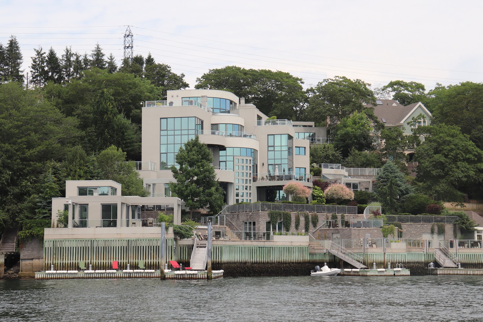
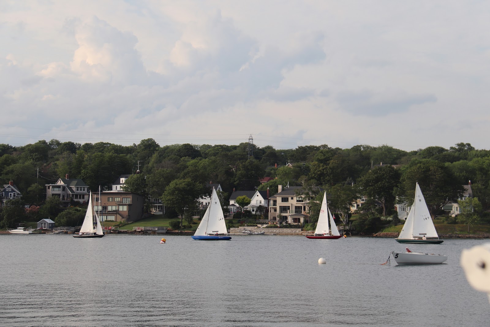
The reason Halifax became historically central and such a pivotal place was due to it's deep and protected harbour. For us pleasure craft, the protection is certainly nice, but it does mean that we had about 7 miles to go before we found ourselves at the Armdale Yacht Club where we would speed the next few nights. The journey up the "arm" was not without interesting things to look at. Old decaying WWII fortifications, opulent homes, R.N.S.Y.S, fleets of wooden bluenose sailboats (still very actively raced around here), sailing school fleets, rowers, and much more.
Home or resort/hotel,
often hard to distinguish
We found A.Y.C. a nice place to be, and thoroughly unique in it's own right. Located on tiny Meleville Island (similarly named to the shoal off Kingston), and accessible via a man made causeway.
The docks radiate out like spokes on a wheel from the island, all the way around. The clubhouse was a former wardens house from when there was a prison on the island. The prison building still exists and the club uses as locker storage, each member getting a "cell" to keep their stuff in.
Bluenose fleet racing in the narrow
channel. Most of them wooden
The site has had a long list of other uses in the past from being a family estate, hospital, quarantine station, military prison, prisoner of war camp, recruit training station for the British Foreign Legion and ammunition depot. The place has a similar feel to KYC, comfortable, and casual, and a unique location.
Halifax welcomed our first night there with a fantastic electrical storm. Here we would enjoy a few days, see some sights, have Debbie re-join the crew, do some repairs, and relax a little before continuing our trek west to explore the rest of Nova Scotia.
For any who don't know (I didn't really know much before planning for this trip), the Bras d'Ore Lake (often called Lakes) is an inland salt water lake on Cape Breton that is connected to the outside via two natural channels on the north east, and by the man made St. Peter's canal that enters from the Strait of Canso at the south-west (this is how we arrived and departed).
It is a beautiful escape to a cruising ground that is protected from ocean swell and has may islands to explore and anchor at. Similar to the Thousand Islands in that there are secluded anchorages everywhere, but different in that there is good sailing to get to each anchorage. It's not hard to find a nice 15-30 nm sail to get to your next anchorage.
Some scheduling issues meant that we had a few days with Bob, Tarja, Chris M., Linda and I before Tarja had to drop Chris M. off and Shediac (where he had left his car when he joined the expedition) and pick up Ben who was flying into Moncton (many thanks to Tarja for being such a trooper doing so much driving). This meant a few days cruising and then back to St. Peter's for an exchange of crew.
As an extra bonus, we had plans to meet with friends and fellow KYC'ers, Peter and Ze, and they had a wedding to attend in Nova Scotia, and were going to treat us to a few days of driving and exploring Cape Breton, where Ze grew up!
St. Peter's
Teamwork?
Locking through
We departed Hawksbury bound for the town of St. Peter's. To get there, we would have preferred to take the inside passage between Ile Madam and mainland Cape Breton, but the swing bridge that would make that possible was not yet finished.
The sail on the outside of Ile Madam was nice and the winds were cooperative.
Crammond Islands
Small wharf and old building
from a time gone by
So after a night at St. Peter's we set out for some nearby anchorages so that we could end up back at St. Peter's where Tarja had left her car. First stop ... the Crammond Islands. This was about 20 nm away down the SW arm of the lake. We had a great sail, with building winds.
Marble Mountain?
Before we got there we stopped by "Marble Mountain". There are marble & gypsum veins all over the landscape here. This location was reputed to have clear waters that looked particularly vibrant with the white marble rock in bottom. While we did find the location, we didn't get the spectacular view we were hoping for. What we did find was the remnants of a quarry and a mine with signs that this was a big operation some time in the past.
Windy out there,
nice in here!
From there, we continued a few more miles to find our anchorage tucked between the Crammond Islands. It will breezy all night, but we were well protected and had a nice evening. Chris hopped in Bob's inflatable kayak and explored the area.
Beaver Island
Since we had to get Tarja back to St. Peter's Marina first thing the next morning, this anchorage needed to be close by. For this we chose to anchor behind Beaver Island.
It was a flat calm evening and very pleasant. Linda and I dropped the dinghy down and did an evening explore around the island. We saw several jumping fish, likely targeting the many insects at dusk.
Back to St Peter's
Heron with the best view!
We left our anchorage at 7am to get to St Peters and drop off Chris M. and Tarja. Tarja (chauffeur extraordinaire!) would spend the day driving, first to drop Chris M at his car in Shediac, and then to Moncton to pick up Ben at Moncton Airport. Linda and Bob did some provisioning.
The local bakery was open and Linda was delighted to discover it made the baked goods in the authentic German style. They even had "Bienenstich" pastry, one of Linda's dad's favourites.
Jetski, dock whips!! abomination
I busied himself with various boat repairs, a full topside cleaning and maintenance.
Tarja and Ben arrived back at St Peters around 7pm, and Linda had our boat-made lobster Mac and Cheese with Bacon waiting for them (made with lobster we had purchased along the way, perhaps in Escuminac)
Baddeck
With the crew exchange complete and Ben on board, we left St Peter's the next morning headed for Baddeck. The weather was lovely and we had enough wind for a close reach. Ben sailed on Ramble On with me, and Linda sailed with Bob on Finnish Line so he wouldn't have to solo it. Tarja drove and met us at the dock in Baddeck.
Finnish Line clearing the
Barra Strait bridge
Along the way, we needed to pass through Barra Strait. There is a double lift bridge for the highway and a swing bridge for the rail. The rail bridge is left swung open, until a train needs it. The lift bridge is used for car traffic but opened on demand for boats that cannot pass underneath. The bridge operator is very pleasant and casual. We radioed as we approached and the bridge was open when we arrived. Just before the Barra Strait, on the south shore near McKinnons Harbour, were huge, striking patches of white, outcroppings of gypsum.
Protected harbour with mooring field
We were able to continue our sail until the final approach to Baddeck harbour. As we got close, you could see the large striking property of Beinn Bhreagh, the home of Alexander Graham Bell! The Beddeck harbour is really pretty--an idyllic bay behind Kidston Island.
' There is an iconic lighthouse at the point, yachts of all shapes and sizes at mooring balls, a large wharf with a tall ship so tourists can go for a day sail, and to top it off, a local resident playing bagpipes (we later found out that he not only plays at the wharf, but walks the streets of the town, playing all the way)!
Ramble On @ Baddeck Marine
So cool, want one!
We stayed at Beddeck Marine, and will keep the boats here when we explore the Cabot Trail by car for a couple of days. The marina had recently undergone some construction for a new travel lift, so the grounds ashore were a little disorganized and muddy, but there is a nice marine store and washrooms, and laundry.
Kidston Isl Light
Kidston Island has a small wooden lighthouse at the north-east end. The Lions Club operates a small swim beach at that end as well, and organizes a pontoon ferry boat to run kids back and forth from the mainland. There is a changing station and lifeguards as well. Ben and I hopped in the dinghy to head over to explore. Once there we found trails through the woods one of which took us through to the other side of the island and then out to the lighthouse and then back.
Another highlight of being in Baddeck was heading to the Alexander Graham Bell Museum and taking some time to learn more about his time and continuing inventiveness while living in Baddeck. He spent much time working on hydroplanes, kites and airplanes. There was a full reproduction hydroplane (the "HD-4") as well as portions of the original that had been sitting on the beach at his Beinn Bhreagh estate from the early 1900's after the tests where completed until much later. The Canadian Navy built an experimental hydrofoil submarine hunter (1968-1971) named the Bras d'Ore as a nod to Mr. Bell!
Beinn Bhreagh (hard to see)
Aside from the well known pursuits, Bell had broad interests much of which stemmed from his father and corresponding early work in teaching deaf people to speak and in a "Visible Speech" program he developed.
Cape Breton Exploration by Car
Over the next few days we were going to get a personalized tour of Cape Breton from the point of view of a local (Ze), but first we had a boat pizza night with the who gang on Ramble On. We've done this a few times, and it's been a real treat. Dough made on the boat, local seafood toppings (bought next door to the marina from Captain Caper's Fish & Chips) as well as other gourmet pizza varieties. Having the round "kettle" style BBQ work well for this, but it is a "one at a time" affair so a different pizza slice arrived about every 10 minutes!
Following our intrepid leader!
The next morning, Peter and Ze arrived back at the marina where we loading into their's and Tarja & Bob's cars and our driving tour began. For most of us, we were passing places names we had only seen on maps before: Mabou, Inverness, Margaree Harbour etc. This took us right past the Glenora Distillery where we stopped for a tour, lunch and a tasting. The distillery also boasts a Inn right on premises, and the grounds and facilities were top notch.
Avoid the one on the left!
The tasting was interesting as it started with an unaged whiskey, strait from the still. This stuff was awful and in my mind tainted the rest of the tastings. It was only after abandoning any hope of finishing that first sample, and letting it's taste fade away that some of the others began to show some promise. In the end, I picked up a bottle of the "Battle of the Glen". So named for the nearly 10 year legal battle with the Scotish Whisky Association that argued that they weren't allow to have "Glen" in the name.
Feet in the water at Inverness
From there we continued our driving tour, stopping a scenic lookouts and various placed along the way while passing by or through places like Maragaree Harbour, Grand Étang, Cheticamp and Petit Étang until we formally entered Highlands National Park.
Skyline Trail The scenery along this shore became steadily more dramatic as we progressed. The shoreline cliffs and geology became progressively taller and more beautiful. The focal point of the day was our stop for a hike on the Skyline Trail. This was a 5 km hike through scrubby and and stunted forests but with the terminus at the most spectacular peninsula with a vista with few equals.
Pleasant Bay
That evening, with everyone a little tired, we found our destination for the night. This was the "pinkest" hotel around called the Midtrail Motel & Restaurant located just at north edge of Highland National Park in Pleasant Bay. We ate at the hotel restaurant, and conked out in our rooms for a well deserved sleep.
The next day we continued our exploration of the north-east end of Cape Breton passing though places like Meat Cove, Aspy Bay, Dingwall, then back down into the park area to Ingonish.
Visitor keeping distance from corpse
Along the way we stopped at Cabot Landing Provincial Park. A small park with a nice beach.
Of a personal note, Ze's grandfather had made some of the bronze plaques on display at the park. It is thought that John Cabot may have landed in this vicinity. We enjoyed stretching our legs here with a short walk along the beach.
Ingonish Our plan was to head to the Keltic Lodge for a hike along the "Middle Head" hiking trail, but first we passed our lodging for the night so we stopped at the Driftwood Lodge to get ourselves checked in. A quaint place right along the shoreline with a slightly hippie feel about it. We could see the Keltic Lodge across North Ingonish Bay. This is where we were heading next.
Middle Head Trail
Don't ... be Superman?
To get to the trail, you enter the Keltic Lodge grounds and continue past the various posh resort buildings until you get to the beginning of the trail. This trail spent a good amount of time going through wooded areas with rough rocky and rooty paths. As it progressed, and we worked out way further out and up on the peninsula the woods began to clear and we could see the rocky shoreline on each side. Again, the end of the trail was marked by spectacular views in all directions looking down on the rough Cape Breton shoreline.
Soaking in the view
We departed the Keltic Lodge site and headed back to scout for someplace to eat. Along the was stopped for some shopping. After some asking we identified our place to eat (where the locals go) and we had hearty servings of seafood! After that, we drove back around the bay again, but this time we were going into the Keltic Lodge to listen to some music. A guitarist and local fiddler put on a great show that had everybody tapping their feet at one point or another.
Back to Baddeck and to Ben Eoin
clubhouse
The next morning, we had to get back to Baddeck to rejoin our boats and continue our voyage. Our next destination was Ben Eoin which had us heading back through the Barra Strait bridge, and then turning north-east to head up the East Bay of lake to the Ben Eoin Yacht Club & Marina.
This will be the eastern most point in our adventure. We hit the northern most point going along the Gaspe peninsula (440nm west and 300nm north of Kingston), and Ben Eoin represents about 700nm east and 100nm north of Kingston. New York will be the most southerly point, and Oswego will be the most westerly point. This point also represents about 1400nm (2600km) of distance traveled. This is just over half way in mileage and in day.
Ben Eoin Harbour
The club has the newest facilities we had experienced so far. The docks, electrical, buildings, and grounds were immaculate. It was here that we had a second KYC re-union of sorts. Tom and Sue, who we had "found" in Bouctouche, had indicated that might be heading to the Bras d'Ore Lakes and sure enough were able to get to the club shortly after we arrived (though they had to navigate through the start of a evening race which they start from the shore at the mouth of the harbour!) In addition to that Rick and Laura we also able to make it to the club after setting up camp at Mira River Provincial Park where they were camping on their maritime camping vacation. We ate with the whole gang at the club that evening.
We made plans with Rick and Laura to informally meet up at Louisbourg Fortress historic site the next day.
Louisbourg Fortress
Sea facing entrance gate
The next day, after about an hour drive, we arrived at the fortress entrance and parking area. This was my first time here, and it is an impressive site. The current building were re-built from barely more than rubble in the 60's and 70's putting the unemployed coal miners to work. The scale of the building project in hard to fathom. The King's Bastion itself is a massive building that must be a 1000' long. Let alone the rest of the small city that has been reproduced.
We had an enjoyable day wandering the village, looking at the various snapshots back in time, talking to the period dressed staff (who spoke and played their period part when they interacted with you).
The Kings Bastion
We bought some locally made bread and ate lunch in the peasants restaurant which fed you authentic food for the period in a building with tables and table ware appropriate to the time.
Preparing to fire!
Very much looking
the part
A highlight to the day was getting Ben signed up to participate in the cannon firing exercise. You pay a small fee for this activity, but they dress you up in 1745 period costume, and provide you with a hour of training before you get to light the cannon as part of the gunnery crew for all visitors in the fort to see. Ben more than looked the part with his long hair in a pony tail under his tricorn hat. (skip to about 3:40s for the real excitement)
We returned to the marina after bidding Rick and Laura adieu and good travels in their camping expedition. Everyone was a little tired and sun baked. The next day we would be heading back to St. Peter's Marine for our last night in the Bras d'Ore Lakes before heading back out through the canal to continue our journey westward along the eastern shore of Nov Scotia.
Obediently lined up to enter
Single file only
In the morning, we found a busy line up to get through locks. There were three sailboats and three motor boats waiting to exit the lakes. Once the very large motor boat cleared the canal coming in, the 6 of us quickly scooted in and got ourselves tied up for the short drop down to ocean level.
Locking through was easy and calm as it was when we entered.


 From our departure form the Bras d'Ore Lakes until we get to Halifax will require almost 200 nm of sailing with much of it along coastline that is rugged and has relatively few harbours for recreational boats. In fact, we planned to anchor our each night until we reached Halifax. Our final departure point from Nova Scotia will be Yarmouth or perhaps Clarks Harbour, and that will be almost 400 nm of sailing.


 Our next stopover on the eastern shore was another 50 nm away. We have been scouring the charts and the ActiveCaptian resources along this shore to locate anchorages. While there may be 1000's of places to hide out and drop an anchor but seeing a location marked with an anchorage or having a review confirming good holding gives you peace of mind. The shores here are rocky, and unforgiving.


 We crept our way into Shelter Cover. The entrance was only 300' feet wide, and the length of the cove was probably not more than 800' long. We had a few of these narrow channels to navigate today, so away from the wind and swell, this was no longer a navigational challenge. Now if we had relied on paper or electronic charts alone we probably would not have entered this cove. The charts all reported just a few feet of depth to get in. One of the very helpful additions to the electronic charting products you have now is crowd sourced reviews. We have relied on ActiveCapitan reviews for many of our anchorages and decision making on this trip. There was a recent posting that the depth into Shelter over was 20+ feet and that the charts were not accurate. We did proceed very slowly into the cove, but we didn't see less that about 22 feet.

 Fresh off a few days of fog navigation, we didn't hesitate in departing in the fog from Shelter Cove. We continued to exercise caution in route planning and navigation. Again we were blessed with a day of complete fog that followed us until we were at the mouth of Jeddore Harbour were the shoreline, houses, and other features began to appear in a sunny haze.

 Now, throughout these fog bound legs, Bob was keeping his eyes on his radar. A couple of times he radioed to let me know about things I couldn't see. Many boats have AIS, but fishing boats, at least the smaller ones, do not, and other recreational boats may or may not have it. Radar sees everything else.